Cinematic 3D Models on a Map
Integrate your high-fidelity glTF 3D models into a global map. Build interactive applications for flight tracking, real estate developments, and site security.

Dynamic architectural 3D animation
Build authentic 3D real estate visualizations, floor by floor, building by building. Create an interactive map of entire blocks of buildings that can be highlighted on hover, animated, and moved aside on click.
Interaction-driven 3D models
Gamify your maps with interactive 3D modules that tilt, roll, animate, and respond to their surroundings.
Leverage collision events to trigger custom functions when models intersect, allowing you to build everything from interactive spatial guides to reactive, map-based simulations.

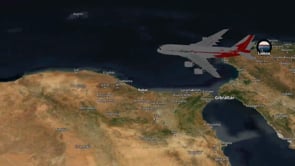
Cinematic path visualization
Animate multidimensional routes with a dynamic camera that follows the journey in real-time. Whether it’s a high-altitude flight or a ground-level drive, provide clear spatial and temporal context by syncing 3D transport models with precise path data.
Real-time models interaction
Visualize rapid response units on a realistic 3D map. Deploy, clone, and manage multiple glTF models simultaneously, with dynamic logic to handle real-world telemetry, such as removing assets upon signal loss.

3D maps
Add your models on top of our 3D maps with extruded buildings and 3D terrain.

GeoSplats
Create your own photorealistic 3D visualizations from drone, mobile, or handheld scans.

Build interactive maps with 3D models
Learn how to add 3D objects from glTF/glb files to your basemap.