
Global datasets for instant integration
Combine and style curated vector and raster datasets - all pre-processed for instant use in your maps.

Planet
Our global dataset includes streets, houses, natural phenomena, political boundaries, and more. The majority of our maps use it as a keystone.

Satellite
Satellite map of the entire world and high-res aerial imagery of the USA, Western Europe, Japan, and other selected regions.

How it works

Select dataset

Create map style

Use on the website
Documented schema for cartographers
Vector tiles schemas of layers and attributes for styling maps.
Outdoor
Map data for summer and winter outdoor activities. The dataset includes map features for hiking, biking, skiing, and cross-country skiing.

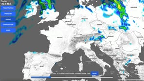
Weather
Weather forecast of the entire world: rain, wind, cloud coverage, temperature, and waves for your maps.
Terrain datasets
Terrain RGB for DEM
Elevation data encoded into the RGB model. Ideal for creating Digital Elevation Models.

Contour lines
Contour lines in meters and feet for outdoor map where terrain matters.

Hillshade
Relief of mountains to add a 3D feel to your maps. Ideal for topographic, outdoor, and hazard maps.

Terrain 3D - Cesium quantized mesh
3D visualizations for direct use with the Cesium JavaScript library.

Countries
Boundaries and postal codes for your data visualization projects.
Connect to your statistical data to display them in a geographical context.

Planet Lite
Global mid-res dataset that can be used without any attribution.
An excellent choice for videos, print, web, and games.

Buldings
An enrichment layer for the Planet dataset that enables feature-level cartography, such as highlighting individual buildings or entrance points. It is ideal for high-detail site plans, conference venues, or industrial facilities.

Land
A polygon covering the entire terra firma, the dry land.
It can be used to create remarkable effects on coastlines.

Ocean
We offer vector and RGB bathymetry datasets to make perfect Ocean maps.

Landcover
Global dataset with generalized forests and other natural areas.
Detailed landcover in the USA and Canada.
Part of the Planet dataset.
OpenMapTiles
OpenStreetMap without unnecessary additional data.
The best dataset for open-source enthusiasts.

National datasets
Authoritative datasets produced by national mapping authorities.
Published on MapTiler Cloud and regularly updated.


The Netherlands
Cartiqo dataset with data from CBS: Centraal Bureau voor de Statistiek, and a topographic raster map.
Use now
Start using datasets
Pick any dataset or ready-to-use map and start crafting your map.