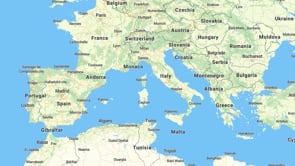
Streets for transportation and logistics
Designed for navigation; used for logistics, fleet management, and deliveries. Streets is the map to navigate you through traffic on foot, on a bike, or in the car.

Dark and Pastel maps for transport


Fonts for any language or script
High-quality multilingual fonts support a global language set for cartographers and designers.
Adaptable font weights and sizes ensure readability.
Over 70 languages are available on MapTiler maps, with fallback fonts for edge cases.
Familiar road labels for each country
Highway shields and underground or subway lines, are matched to the styles found locally.
Your maps will have a familiar feel for your users, with recognizable colors and shapes for every country.
Using MapTiler Streets makes it simple for your users to orientate themselves on a global navigation platform.

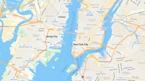
Last mile detail
Take the guesswork out of navigation! Streets has all the information needed to pinpoint addresses in an increasing complex world.
Detailed 3D buildings, house numbers and parking entrances are all on the map leading people directly to where they want to go.

Dark mode maps for transport
With colors tuned for night-time navigation, journeys can be just as smooth and reliable as during the day.
The switch to Dark mode can be done with a single line of code using the MapTiler SDK.
Set it to change with the time of day, device system settings, or even when your route takes you through a tunnel!

More detail at every scale
Streets brings rich data and labels at every map scale without feeling cluttered.
From global to local, every zoom level is optimized to have the right amount of detail for decision making.
Available as:


Start using Streets via Maps API
https://api.maptiler.com/maps/streets-v4/?key=YOUR-API-KEY